All pictures are thumbnails
A stained glass window at Blandford Church, Petersfield
Civil War Odyssey
The original idea behind this part of my web-page was to show the ground over which the Palmetto Sharpshooters fought so that others who are not able to visit the sites have an idea what they look like.
It would have been nice to show all sites but time precluded this. I have included other pictures taken at these battlefields as this would seem the correct place to include them. Much of the Richmond
and Petersburg battlefields are overgrown and photos were not taken. If the viewer has trouble understanding any of the text I suggest they read the unit history on this web-page.
The battlefields visited are in the care of the National Park Service, established in 1916.
The NPS consists of 379 centers located in just about every state and territory.
The facilities at the parks usually consist of a main visitor center which houses exhibits, an audiovisual center, a bookshop,
and staff to assist the visitor. In the outlying areas the centers are small, usually staffed by one person with a small bookshop,
sometimes with a few artifacts. The parks are open from dawn to dusk throughout the summer months with the centers open from 0900 to 1700.
The Richmond National Battlefield Park has recently had a donation of 700 acres at Malvern Hill
and Fraiser's Farm and 230 acres at Beaver Dam Creek. This to add to the already held 763 acres is an increase of 122%. Needless to say they have had no time to incorporate these new acres into their existing tour. Other parks are also expecting donations thus also increasing their acreage.
All the parks visited provide a tour guide. Some of these guides, Richmond
and Petersfield for example, if followed can just about be completed in a day.
Williamsburg (Fort Magruder)
The Palmetto's fought in Fort Magruder during the battle.
What little remains of the fort now lay in the grounds of the Radisson Hotel, Williamsburg, with the remainder of the battlefield laying in the grounds of private houses, parts can just be seen by looking over fences.
All that remains of the fort’s very overgrown.

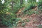
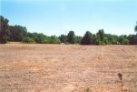
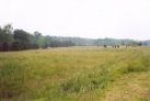
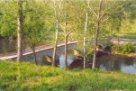
Gaines Mill (Cold Harbor, Chickahominy)
A roadside marker and the field the Palmetto's fought in after having crossing boggy ground,
and climbing a hill . They then marched out of the woods to the right of the picture, with the 16th Maine coming out from the woods to the left.
They met somewhere in the open space in the middle.

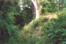
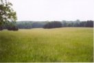
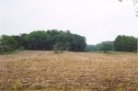
Frayser's (Fraiser's) Farm (Glendale, White Oak Swamp, Charles City Crossroads, Nelson’s Farm, Turkey Bend/Bridge, New Market Crossroads, Willis Church, Riddell’s Shop)
A roadside marker and the field that the Palmetto's launched their attacked from.
This was launched at the farthest point on the far left that you can see. The woods that cover the area that they fought in have recently come into the hands of the
‘National Parks Service’.
2nd
Manassas (Bull Run)
The Palmetto's battle line ran approximately behind the clump of trees to your front.
The end picture looks along the battle line, with the first pictures trees are on the far right. In the middle is the unfinished railroad cutting held by
'Stonewall' Jackson's Corps for a day.
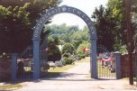
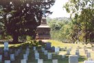
Fredericksburg
The ground the Palmetto’s held is so overgrown no photo was taken.
The first picture in the top line is of the Confederate Cemetery and the last Confederate graves, showing the monument.
These flank all that remains of the 'Stone Wall', although a new wall has been built behind the camera position on the foundations of the original.
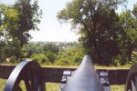
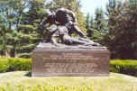
The bottom line has the Federal guns at Chatham House, which look towards Fredericksburg showing the church steeple as it was at the time; in the centre the memorial to the
'Angel of Marye's Heights'; and lastly the Pyramid built by railway workers showing the furthest advance of Major General George G. Meade's Divisions breakthrough.
Sharpsburg(Antietam)
The top line shows a marker that tells the Palmetto's defensive position; the stone foundations of what's left of the mill
and stone house which was that position. These are situated to the left, just a few hundred yards from Rohrbach's (Burnsides) Bridge; the second marker at the bridge commemorating its defense by Georgia Regiments with the mention that a company from Brigadier General Micah Jenkins Brigade helped in its defense, as the Palmetto's were the sharpshooters in the Brigade it's just possible that the company came from the unit; finally the bridge.
The second line shows 'The Cornfield'; the 'Sunken Road (Bloody
Lane)', looking along its main length with the second picture taken from a tower (this is the position of the Federal troops who enfladed the position); with the
'Dunker Church' last.
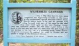
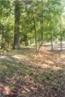
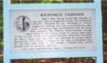
The Wilderness
The first picture show the position of Lieutenant General Richard S. Ewell's Corps on the Orange Turnpike, looking towards the Federal positions.
Near this spot is the marker commemorating the wounding of Lieutenant General James Longstreet (it is in the same place, and at the same time, that Jenkins is mortally wounded.)
On the second day of the battle the Palmetto's for a brief time before 1700hours raised their battle flag on these ramparts, this the last marker commemorates.
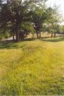
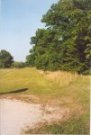
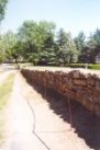
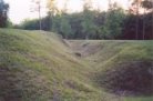
Spotsylvania Court House
Time being short and having heard so much about ‘The Mule Shoe, Bloody Angle’ somehow it seemed only right to to visit this spot instead of just find some clump of trees and this is the photos depicted here.
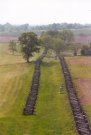
The Palmetto's position was about 3/4 mile to the left of left hand picture.
As will be seen the trench lines are almost lost back into the ground from whence they came but the outline is helped by not cutting the grass that grows on them.
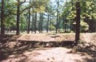
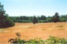
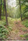
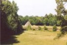
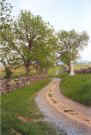
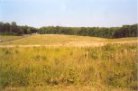
Cold Harbor
The battlefield that is in the hands of the NPS is very small and the Palmetto's position is in private hands but I have included this photo because it gives an idea what the terrain is like today with trees covering so much, as well as being heavily overgrown.
Here the undergrowth has been cut away. This photo is taken at approximately where the Federal VI Corps attacked, 3 June 1864, and sustained such losses.
The Federal trenches are only 300 yards away and can be seen in the distance.

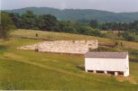
Fort Harrison
The fort is the least overgrown, and largest, one visited.
After it's capture it was modified by Federal troops. It is in responding to its loss that in this area the Palmetto's unsuccessfully attacked.

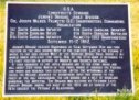
On a monument to South Carolina’s troops at Confederate Fort Gregg.
![]()
